Bäuerinnen, Förster, Investoren und Stimmbürgerinnen prägen mit ihrem Verhalten und ihren Tätigkeiten die Landschaft. Daher lohnt es sich genauer hinzuschauen, was genau diese Akteure machen und welche konkreten Auswirkungen sie auf Landschaft und Ökosysteme haben.

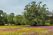
Wiesen können fett oder trocken sein, blumenreich vielfarbig oder uniform grün. Neben Standortfaktoren ist es die konkrete landwirtschaftliche Praxis, die dafür verantwortlich ist. Wie oft wird gemäht, wie stark gedüngt, wie lange beweidet und mit welchen Tieren – all diese Faktoren bestimmen schliesslich welcher Wiesentyp vorliegt. Dasselbe gilt analog für Wälder, Obstanlagen, aber auch das Umgebungsgrün im Siedlungsbereich: Die Gärtnerin entscheidet sich für Blumen oder Gemüse, für exotischen Kirschlorbeer oder einheimischen Liguster. Die Art und Intensität der Landnutzung bestimmt somit die ökologische, aber auch ästhetische Qualität einer Fläche.
In verschiedenen Projekten gehen wir der Frage nach, wie die Intensität der Landnutzung erfasst werden kann, welche Faktoren sie prägen und welche Folgen dies für Landschaften und Lebensräume hat.
Kontakt 

Publikationen 
Opravil Š., Pazúr R. (2022) Mapping of management practice on permanent grassland using sentinel-2: a case study of Nothern Slovakia. Geogr. Časopis. 74(4), 299-315. https://doi.org/10.31577/geogrcas.2022.74.4.15 Institutional Repository DORA
Helfenstein J., Bürgi M., Debonne N., Dimopoulos T., Diogo V., Dramstad W., … Herzog F. (2022) Farmer surveys in Europe suggest that specialized, intensive farms were more likely to perceive negative impacts from COVID-19. Agron. Sustain. Dev. 42(5), 84 (16 pp.). https://doi.org/10.1007/s13593-022-00820-5Institutional Repository DORA
Weber D., Ritter L., Ginzler C. (2022) Webcam-Bilder als Referenzdaten für die satellitengestützte Beurteilung der Grünlandnutzung. Geomat. Schweiz. 120(5-6), 106-108. Institutional Repository DORA
Pazúr R., Price B., Atkinson P.M. (2021) Fine temporal resolution satellite sensors with global coverage: an opportunity for landscape ecologists. Landsc. Ecol. 36, 2199-2213. https://doi.org/10.1007/s10980-021-01303-w Institutional Repository DORA
Meier E.S., Indermaur A., Ginzler C., Psomas A. (2020) An effective way to map land-use intensity with a high spatial resolution based on habitat type and environmental data. Remote Sens. 12(6), 969 (21 pp.). https://doi.org/10.3390/rs12060969Institutional Repository DORA
Pazúr R., Lieskovský J., Bürgi M., Müller D., Lieskovský T., Zhang Z., Prischchepov A.V. (2020) Abandonment and recultivation of agricultural lands in Slovakia - patterns and determinants from the past to the future. Land. 9(9), 316 (22 pp.). https://doi.org/10.3390/land9090316Institutional Repository DORA
Tobias S., Price B. (2020) How effective is spatial planning for cropland protection? An assessment based on land-use scenarios. Land. 9(2), 43 (20 pp.). https://doi.org/10.3390/land9020043Institutional Repository DORA
Goga T., Feranec J., Bucha T., Rusnák M., Sačkov I., Barka I., … Vladovič J. (2019) A review of the application of remote sensing data for abandoned agricultural land identification with focus on Central and Eastern Europe. Remote Sens. 11(23), 2759 (19 pp.). https://doi.org/10.3390/rs11232759Institutional Repository DORA
Gerecke M., Hagen O., Bolliger J., Hersperger A.M., Kienast F., Price B., Pellissier L. (2019) Assessing potential landscape service trade-offs driven by urbanization in Switzerland. Palgrave Commun. 5, 109 (13 pp.). https://doi.org/10.1057/s41599-019-0316-8Institutional Repository DORA
Kolecka N., Ginzler C., Pazur R., Price B., Verburg P.H. (2018) Regional scale mapping of grassland mowing frequency with Sentinel-2 time series. Remote Sens. 10(8), 1221 (19 pp.). https://doi.org/10.3390/rs10081221Institutional Repository DORA
Sauter I., Kienast F., Bolliger J., Winter B., Pazúr R. (2019) Changes in demand and supply of ecosystem services under scenarios of future land use in Vorarlberg, Austria. J. Mt. Sci. 16(12), 2793-2809. https://doi.org/10.1007/s11629-018-5124-x Institutional Repository DORA
Price B., Kienast F., Seidl I., Ginzler C., Verburg P.H., Bolliger J. (2015) Future landscapes of Switzerland: risk areas for urbanisation and land abandonment. Appl. Geogr. 57, 32-41. https://doi.org/10.1016/j.apgeog.2014.12.009 Institutional Repository DORA
Busch V., Klaus V.H., Schäfer D., Prati D., Boch S., Müller J., … Kleinebecker T. (2019) Will I stay or will I go? Plant species‐specific response and tolerance to high land‐use intensity in temperate grassland ecosystems. J. Veg. Sci. 30(4), 674-686. https://doi.org/10.1111/jvs.12749 Institutional Repository DORA
Corona R., Galicia L., Palacio-Prieto J.L., Bürgi M., Hersperger A. (2016) Local deforestation patterns and driving forces in a tropical dry forest in two municipalities of southern Oaxaca, Mexico (1985–2006). Inv. Geogr. 91, 86-104. https://doi.org/10.14350/rig.50918Institutional Repository DORA
Li L., Fassnacht F.E., Storch I., Bürgi M. (2017) Land-use regime shift triggered the recent degradation of alpine pastures in Nyanpo Yutse of the eastern Qinghai-Tibetan Plateau. Landsc. Ecol. 32(11), 2187-2203. https://doi.org/10.1007/s10980-017-0510-2 Institutional Repository DORA
Bürgi M., Li L., Kizos T. (2015) Exploring links between culture and biodiversity: studying land use intensity from the plot to the landscape level. Biodivers. Conserv. 24(13), 3285-3303. https://doi.org/10.1007/s10531-015-0970-0 Institutional Repository DORA
Diacon-Bolli J., Dalang T., Holderegger R., Bürgi M. (2012) Heterogeneity fosters biodiversity: linking history and ecology of dry calcareous grasslands. Basic Appl. Ecol. 13(8), 641-653. https://doi.org/10.1016/j.baae.2012.10.004 Institutional Repository DORA