1. While many studies on insect diversity report declines, others show stable, fluctuating or increasing trends. For a thorough understanding of insect trends and their effects on ecosystem functioning, it is important to simultaneously assess insect richness, abundance and biomass, and to report trends for multiple taxa.
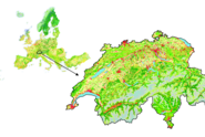
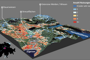
2. We analysed insect richness, abundance and biomass data for all insects and for eight insect taxa (Buprestidae, Cerambycidae, Carabidae, other Coleoptera, Aculeata, other Hymenoptera, Heteroptera and Lepidoptera) from 42 sites across Switzerland from 2000 to 2007, representing three major habitat types in Switzerland (agricultural, unmanaged [open and forested] and managed forest habitats). As potential drivers of temporal patterns, we evaluated weather- and land-use-related factors. As predictors, we included temperature and precipitation as well as the vegetation index and the habitat type, respectively.
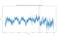
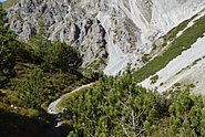
3. We found a consistent pattern of stable or increasing trends for richness, abundance and biomass of insects in total and the eight taxa over 8 years. Both overall patterns and six out of eight taxa (except for Cerambycidae and Lepidotpera) showed the highest values in agricultural habitats. However, when accounting for elevation, there was no difference in open habitats regardless of whether they were used agriculturally.
4. Habitat types were the most important predictors, followed by weather- and vegetation-related factors. Modelled responses to mean temperature were unimodal, whereas the standard deviation of temperature showed positive and precipitation negative effects. Longer time series are needed to draw robust inferences and to investigate potential negative effects of future warming.
See DOISee Institutional Repository DORA