
06.01.2022 | Cornelia Accola | News SLF
"Reduction methods" have proven to be useful for skiers when planning tours, enabling them to assess local dangers and in turn, to avoid hazardous slopes. These methods were devised primarily on the basis of accident data. A recent study draws accident-free backcountry touring activities into the risk calculation as well. It examines where, and how often, tours have taken place without incident. Addressing these questions allows more accurate avalanche risk assessments and gives rise to findings that are relevant in the context of ski tour planning and behaviour in the field.
Avalanche risk for a specific tour can be calculated by applying decision-making techniques based on specific rules, e.g. Werner Munter’s reduction method. The aim is to identify and avoid the slopes that present the greatest danger from the perspective of their terrain features. These techniques have proven their merit in practice. When these methods were originally developed, no frequency of traffic in backcountry was available, only accident data, so these methods cannot calculate actual avalanche risk. The researchers who conducted the recent study set out to investigate whether the assumptions underpinning the methods were correct. The SLF Interpretation Guide which complements the avalanche bulletin, for example, recommends application of the one-level rule for slopes whose aspect and altitude zone are not mentioned in the avalanche bulletin: "For slopes that do not satisfy both criteria (altitude zone and aspect), it has become customary in backcountry touring to assume the danger level to be one level lower." In addition to this issue, however, another interesting question arises: As the danger level rises, to what extent does avalanche risk actually increase and, as a consequence, what impact does the altitude have on the avalanche risk?
Statistical analysis of more than 2 million movement points in 7,000 recorded tours 
Avalanche risk was defined as the probability of being caught up in an avalanche during a ski tour in potential avalanche terrain (on ascent and descent). In other words, the risk is expressed as the ratio of accidents to backcountry touring activity. The data basis encompassed 784 avalanche accidents in Switzerland, spanning the winter seasons 2005/06 to 2018/19. A large number of accident parameters were examined, including the avalanche path, aspect and average slope angle. These avalanche accidents were compared with 7,000 recorded tours (GPS-tracks) collected by the online portal www.skitourenguru.ch. Ski tours covering a total of more than 20,000 km in potential avalanche terrain represent a large portion, but by no means all of the tours undertaken in Switzerland. The results accordingly reflect the selection of data that were available. In addition, absolute avalanche risk cannot be calculated from the available data, but only the extent to which the risk increases or decreases in response to various conditions.
Results of the study 
For winter sports enthusiasts, statistical analysis resulted in the following useful key findings:
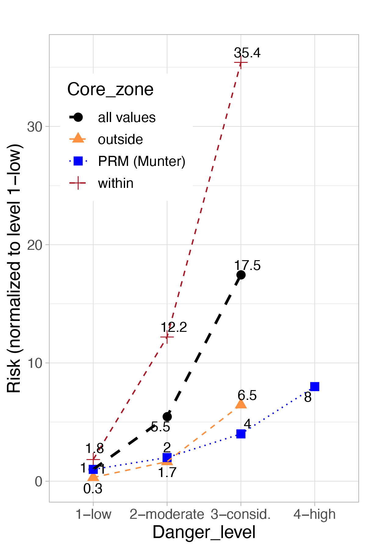
- Avalanche risk increases significantly (approximately fourfold) from one danger level to the next (see black curve in Fig. 1). Measured against the findings of the study, therefore, the ordinarily assumed doubling of the danger potential1 underestimates the extent of the increase.
- On slopes mentioned in the avalanche bulletin with reference to both their altitude and aspect, the risk is around 6 times greater than on slopes that are not mentioned. This indicates that the one-level rule reflects and, in specific circumstances, even understates the lower danger that applies.
- The higher the altitude, the greater the risk. At an altitude of 2700 m, avalanche risk is more than four times greater than at 1900 m. Below 1600 m the risk is small.
Avalanche risk is higher on north-facing slopes than on south-facing slopes, but "only" just about twice as high. This relatively small difference is attributable to north-facing slopes being more highly frequented than south-facing slopes. Here again, the impact of the extent of activity on risk calculation is clearly illustrated.
Conclusion
One of the purposes served by the danger levels is to indicate the prevalence of places in a region where snowpack stability is so poor that an avalanche release is possible. The prevalence of these very weak locations increases with ascending danger level. The analysis of two large sets of data revealed that avalanche risk likewise increases significantly – almost exponentially – with ascending danger level.
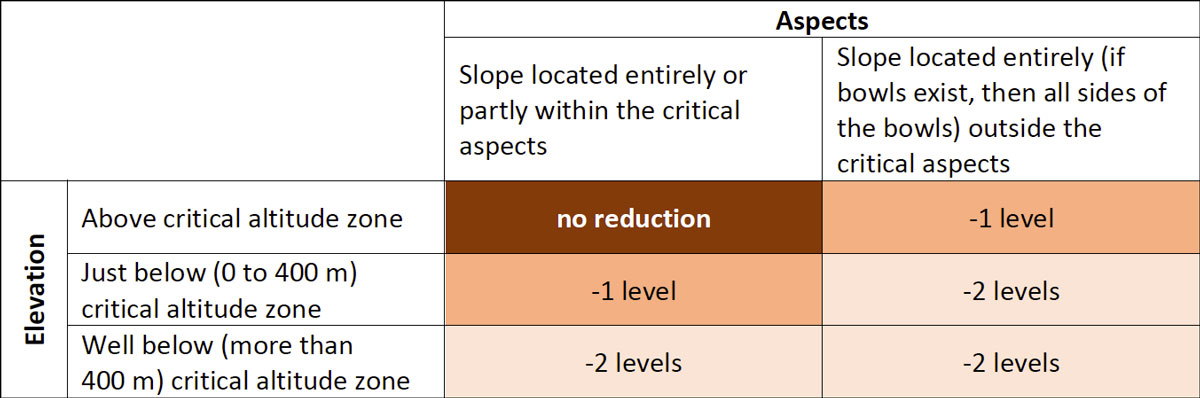
As set forth in the Interpretation Guide, the forecast danger level applies to slopes whose altitude zone and aspect are both mentioned in the avalanche bulletin. The study has confirmed the validity of the one-level rule. On other slopes, the avalanche danger is one level lower, or lower still in some instances. In certain cases, avalanche danger can even be assumed to be two levels lower (see Fig. 2), and that the mean statistical risk therefore decreases accordingly.
Projection and recommendation 
The study demonstrates the importance of adapting ski touring activities to the current conditions. In particular when a tour is being planned, it is good practice to give consideration to the forecast danger level; in other words, to select a tour that avoids slopes in the aspects and elevation zones published in the avalanche bulletin. The study can contribute to improving algorithms and thus automating the planning of tours. In consequence, two benefits can arise. First, the ability of algorithms to interpret parameters in a more differentiated way and thus, to depict the statistical danger more accurately. And second, improved algorithms can simplify tour planning, which it is hoped will prompt an increase in planning.
The task of assessing an individual slope cannot be automated. The statistical risk determined by the methods described above serves as a reference value in this context. Although far from perfect, it represents a good assumption. Using information acquired in the field, the reference value can be adjusted accordingly – either upwards or downwards. The more clear-cut the information, the more reliable the local assessment. As a rule, it is therefore advisable, unless contrary indications take precedence, to follow the recommendation of avoiding very steep slopes within the critical altitude zone and in the critical aspects when "considerable" avalanche danger is determined.
1W. Munter (1997): 3x3 Lawinen. SLF (2021): Avalanche Bulletin Interpretation Guide, graph p. 25
Contact 
Copyright 
WSL and SLF provide the artwork for imaging of press articles relating to this media release for free. Transferring and saving the images in image databases and saving of images by third parties is not allowed.