
19.04.2016 | News
Pierre Cothereau, an environmental sciences student at ETHZ and WSL, developed a novel software tool during his 6 months Master thesis, the Vertical Vegetation Structure Classifier (VVSC). For this, he was rewarded the ESRI Young Scholar Award, which honors academic excellence among students all over the world.

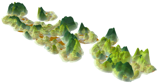
Recent technical advancements in Light Detection and Ranging (LiDAR) remote sensing offers new opportunities and challenges to scientists and researchers. The possibility to measure, quantify and visualize the ecosystem structure in 3D at large spatial scales and at relatively low costs has allowed for new insights in our environment’s structure.
The main goal of this new tool programmed with ArcGIS is to offer the user a visualization of the 3D vegetation structure in areas of interest. VVSC aggregates LiDAR data into different classes of user-defined vegetation heights (woody biomass) and provides the user with multiple information on these classes such as their area, the point density and the spatial distribution of each height classes across the landscape. The aggregation of the height classes is performed in specific user-defined regions. This allows for a broad range of ecological applications in conservation and connectivity research at the landscape scale.
The ESRI Young Scholar Award honors academic excellence among students all over the world. With other young scholars, Pierre has been invited to his work at the ESRI International User Conference in San Diego, which will allows him to exchange experience and to network.
Congratulations, Pierre, to such a wonderfully great success!
Copyright 
Contact 
Links and documents 
Master thesis
Cothereau, P. A. D. 2016. Vertical Vegetation Structure Classifier (VVSC): A novel tool for ArcGIS. Master Thesis ETHZ and WSL. Supervisors: Janine Bolliger and Christian Ginzler, WSL.