
14.04.2025 | Lisa Bose, Stephanie Kusma | WSL News
Where did Switzerland provide space for nature shortly after the Second World War, where were buildings or fields? Researchers at the Swiss Federal Institute for Forest, Snow and Landscape Research WSL have developed a model that can map habitats such as forests, water bodies and orchards from digital aerial photographs of the post-war period. They will now use it to create a historical habitat map of Switzerland.
- Swiss landscapes in transition: WSL researchers have used historical aerial photographs from 1946 to digitally reconstruct the former extent of habitats.
- Mapping with AI: Their computer model has learned to recognise habitats such as orchards, forests or meadows in the historical black and white photos - despite technical hurdles.
- Valuable for nature conservation: The reconstructed habitat maps provide clues as to where species once occurred - and why they are sometimes found in unexpected places today.
- Nationwide mapping: In a follow-up project, the researchers will now apply the model to the whole of Switzerland and to additional dates in the past
Switzerland's landscapes have changed dramatically since the post-war period: Land consolidation, motorways and urban sprawl have changed, destroyed or fragmented important habitats for animals and plants. But how large are the changes from the past to today? "We are often asked this question," says Bronwyn Price from the WSL Remote Sensing Group. Thanks to aerial photographs from 1946, which the US Army Air Forces took in Switzerland after the end of the Second World War and which have been publicly accessible since 2019, the researcher and her team have now investigated it – and developed a computer model that converts the historical images into digital habitat maps.
Typical regions as examples 

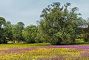
The researchers first examined whether the black-and-white images would help to digitally depict the distribution of the habitats of the time. To do this, they selected eight very different regions that represent typical Swiss landscapes. "Orchards and vineyards are particularly interesting, as their area has changed considerably since 1946 ", says Price.
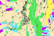
Using expert knowledge, historical maps and additional data, such as the topography or climate of the location in question, the researchers trained a computer model to analyse the images. This wasn’t easy: "For example, the computer initially had difficulty distinguishing rivers from roads, or sparsely wooded areas from ones with buildings." With the help of several control steps, the researchers improved the detection rate. With success: "The model shows how widespread which habitats were in the 1940s in the regions we analysed," says Price.
Important information for nature conservation 

Information like this is important e.g. in nature conservation: "Sometimes species occur outside their traditional habitats, in places where you wouldn't expect to find them," explains Price. "On a habitat map that shows the historical status, you can then see whether the 'right' habitat existed in this location in the past and the species simply hasn't disappeared yet." Experts call this phenomenon extinction debt. A historical habitat map could help to identify such 'debts' and therefore help support endangered populations.
Comparisons with the current digital habitat map of Switzerland, which the researcher and her team developed on behalf of the Federal Office for the Environment FOEN, are also possible. "However, the historical map currently distinguishes fewer habitat types than the current one," Price cautions. The researcher and her team are already working on further improving the model in a follow-up project. For example, artificial intelligence will learn to include the surroundings of 'unclear' objects on the images - such as individual trees or buildings - in the identification process.
One map for the whole of Switzerland 
They will also create a historical habitat map for the whole of Switzerland - and not just for 1946, but also for later dates with the help of new image sources. This will make it possible to analyse patterns and trends in changes to Switzerland's habitats over the past seventy years.
Contact 


Publication 
Huber N., Bürgi M., Ginzler C., Eben B., Baltensweiler A., Price B. (2025) Historical habitat mapping from black-and-white aerial photography: a proof of concept for post World War II Switzerland. Int. J. Appl. Earth Obs. Geoinf. 138, 104464 (13 pp.). https://doi.org/10.1016/j.jag.2025.104464Institutional Repository DORA
Projects 
Copyright 
WSL and SLF provide image and sound material free of charge for use in the context of press contributions in connection with this media release. The transfer of this material to image, sound and/or video databases and the sale of the material by third parties are not permitted.