20.04.2021 | Roman Oester | News SLF
For over 80 years, the SLF has been measuring snow water equivalent (SWE), a metric that indicates how much water is contained in snow. Now researchers are testing a new SWE measurement method, using sensors for navigation satellite systems.
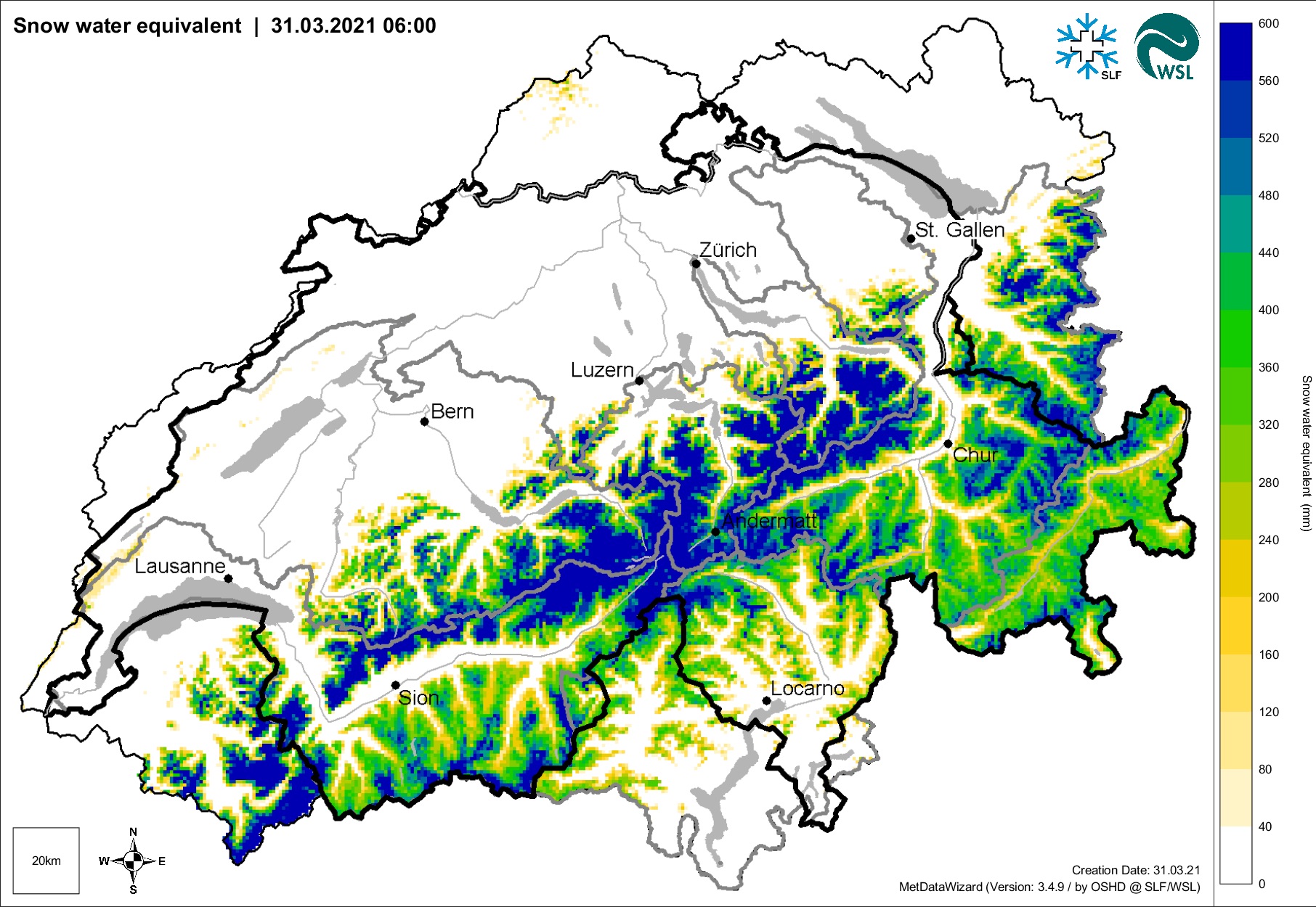
Snow is a natural reservoir and so affects the water resources available for agriculture, power generation and human consumption. Melting snow can be a major factor in floods, such as those that occurred after the avalanche winter of 1999 which left large parts of Switzerland under water. Snow also has a cooling effect on the climate as it reflects a high proportion of solar radiation. It is therefore important to know how much water is stored in the snow. This is measured by a metric known as "snow water equivalent" (SWE). SWE is also one of many climate variables in the Global Climate Observing System (GCOS – see info box).
However, SWE is relevant not only for spring snowmelt and the climate but also for buildings, since it enables the snow load on roofs to be determined, which has an impact on local building regulations. The actual depth of snow does not in itself indicate how heavy the snow is.
Automatic measurements: faster and cheaper 


Conventional – i.e. manual – measurements are time-consuming and expensive, and provide only snapshots rather than continuous data. That is why researchers from the SLF, ETH Zurich, Ludwig Maximilian University of Munich (LMU) and the University of Natural Resources and Life Sciences, Vienna (BOKU) have spent the past few years testing a new method for measuring SWE easily and cost-effectively, with the help of sensors that use signals from navigation satellites (GNSS – see info box). Two GNSS antennas were set up at the SLF's Weissfluhjoch test site above Davos, with similar arrangements in Davos Laret, Klosters and Küblis: one antenna on the ground, which is covered with snow in winter, and the other on a mast that remains free of snow and serves as a reference. When the GNSS signals pass through the snowpack, their properties change: they become weaker and slower. From the difference between the signals received above and below the snowpack, the researchers can calculate the SWE. With this set-up, it is also possible to work out the depth of the snow and the current liquid-water content in the snowpack.
Accuracy checked by means of control measurements 
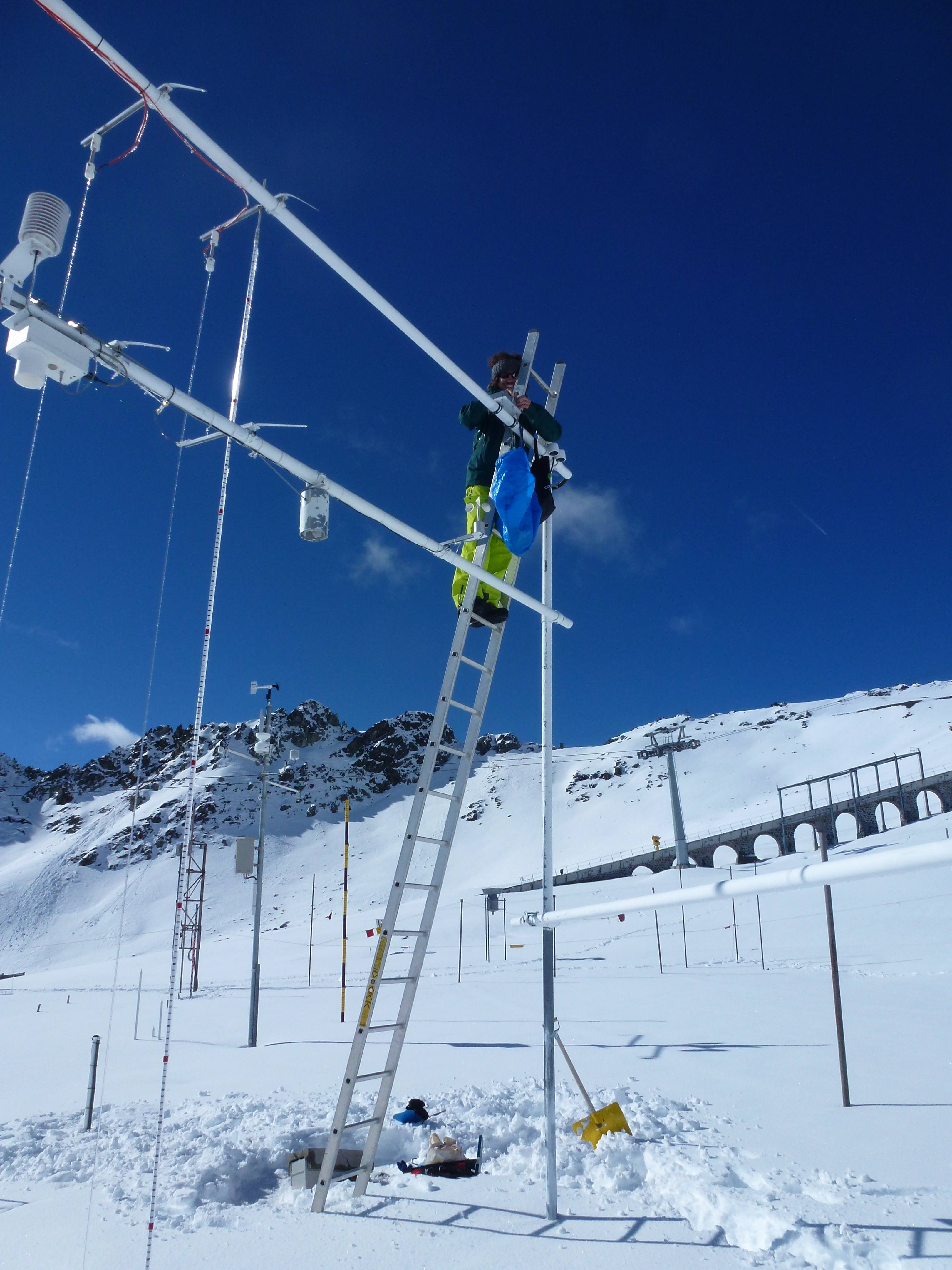
To verify the measured values, various reference data are collected at the monitoring sites. A number of automatic sensors are in place at the Weissfluhjoch site and in Davos Laret, and the researchers have also installed snow depth sensors and cameras in Klosters and Küblis. At all the sites the SWE was also measured conventionally by digging a snow profile and taking snow samples, which are then weighed. This can be used to calculate the depth of the water (in millimetres) that will remain after the snow has melted.
Promising results 
The values obtained closely match the control measurements. Using GNSS sensors could potentially be a simple and cost-effective way of measuring the snow parameters mentioned above at a large number of locations. However, the tests at four different sites and altitudes, from Küblis to Weissfluhjoch, have shown that some improvements are needed before the method is ready for operational use. One issue is the availability of the measured values: while the raw data from the measurements are available immediately, they require complex post-processing to make them suitable for evaluation. However, the SLF sees this approach as the future of SWE measurements and is committed to further developing the method.
For the time being, though, the researchers will still need to carry on shovelling snow and taking measurements in the conventional way.
What is GCOS?
GCOS is the Global Climate Observing System. In Switzerland, it is coordinated by MeteoSwiss; the SLF is one of the partner institutions and supplies the data on SWE. Some of the SLF's long-term SWE measurements and the corresponding research work in this area is co-financed by GCOS Switzerland.
What is GNSS?
GNSS stands for Global Navigation Satellite System and is a collective term for the use of various satellite systems, the best-known being the US-developed Global Positioning System (GPS). For the evaluation of SWE measurements, the researchers combined GPS signals with signals from the EU's GALILEO satellite system.
An abridged version of this article was published in the Davoser Zeitung on 20 April 2021.
Contact 
Links 
Copyright 
WSL and SLF provide the artwork for imaging of press articles relating to this media release for free. Transferring and saving the images in image databases and saving of images by third parties is not allowed.