
Remote sensing-based national forest damage assessment system
Gwendolyn Dasser
Christian Ginzler
Marius Rüetschi
Lars Waser
2020 - 2022
Cooperation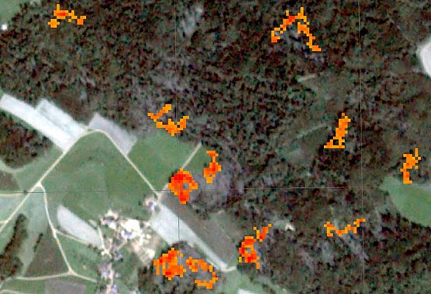
In the FNEWs project, a national remote sensing-based monitoring system for forest damage is being set up. After major forest damage events, data on affected forest areas and arising damaged wood should be provided. The system should enable an automated and nationwide uniform detection of forest damage. In addition, a monetary evaluation framework for the damage recorded is being developed.
The WSL Remote Sensing Group is responsible for work package 5. Active sensors in the microwave range, such as SAR (Synthetic Aperture Radar), are needed to quickly detect forest damage independent of cloud cover. In work package 5 the potentials of Sentinel-1 C-band data are analyzed, demonstrated and operational procedures are designed. Focus of the work is quick detection of windthrown areas. On the one hand, trade-off between accuracy of the detection approach and waiting time for additional (and thus noise-reducing) SAR acquisitions will be investigated. On the other hand, it is of interest what the minimum size of detectable windthrown areas is. This should help to estimate at which point of time which storm damage can be reliably detected. Based on the results of the evaluation, "indication maps" for windthrown areas shall be created.
Further and up-to-date information is available on the project website.
Publications 
Reinosch E., Backa J., Adler P., Deutscher J., Eisnecker P., Hoffmann K., … Oehmichen K. (2024) Detailed validation of large-scale Sentinel-2-based forest disturbance maps across Germany. Forestry. https://doi.org/10.1093/forestry/cpae038 Institutional Repository DORA
Oehmichen K., Ackermann J., Adler P., Backa J., Beckschäfer P., Deutscher J., … Wimmer A. (2024) Ergebnisse des Fernerkundungsbasierten Nationalen Erfassungssystems Waldschäden (FNEWs). (Project Brief Thünen-Institut für Waldökosysteme, Report No.: 2177). Thünen-Institut für Waldökosysteme. 2 p. https://doi.org/10.3220/PB1712056632000Institutional Repository DORA
Weber D., Rüetschi M., Waldner P., Waser L. (2021) Erfassung von Sturmschäden mittels Satellitenbildern am Beispiel des Gewittersturms Bernd: was ist möglich, was nicht? Zürcher Wald. 53(6), 43-47. Institutional Repository DORA
Forzieri G., Pecchi M., Girardello M., Mauri A., Klaus M., Nikolov C., … Beck P.S.A. (2020) A spatially explicit database of wind disturbances in European forests over the period 2000-2018. ESSD. 12(1), 257-276. https://doi.org/10.5194/essd-12-257-2020 Institutional Repository DORA
Rüetschi M., Small D., Waser L.T., Ginzler C. (2019) Lokalisierung von Windwürfen mit Sentinel-1A/B-Daten: ein Versuch nach «Burglind». Schweiz. Z. Forstwes. 170(2), 106-109. https://doi.org/10.3188/szf.2019.0094 Institutional Repository DORA
Rüetschi M., Small D., Waser L.T. (2019) Rapid detection of windthrows using Sentinel-1 C-band SAR data. Remote Sens. 11(2), 115 (23 pp.). https://doi.org/10.3390/rs11020115Institutional Repository DORA