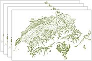
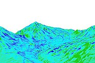
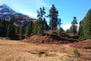
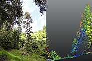
Research Interests

  • Generation of digital elevation models from photogrammetry and LiDAR
  • Field data acquisitions with UAVs, terrestrial laser scanning and surveying methods
  • Processing of the NFI Vegetation Height Model for Switzerland
  • Preparation and post-processing of a variety of remote sensing datasets

Education

  • CAS Spatial Infomation Systems, ETH Zürich 2017
  • Master in Geography at University of Bern 2012
  • Swiss Mountain Guide with federal diploma 2010

Projects

The joint project between Switzerland, Laos, Malaysia and China aims to research and develop the key technologies for forest resources dynamic monitoring and forest volume estimation based on ALS and other related remote sensing technologies.

The aim of the project is to generate annual vegetation height models for Switzerland based on satellite imagery from Sentinel-2. Within the framework of the Swiss NFI, a workflow will be implemented and the accuracy of the resulting products will be estimated.

Information on large scale snow depths is still mainly based on interpolated point measurements. New developments in sensor – and software technology for digital photogrammetry in the last two decades offer new possibilities to derive high resolution, digital surface models (DSM) even over snow covered high-alpine regions.

Die Forschungsstation Seehornwald Davos wurde in den 80er-Jahren von der WSL initiiert und ist damit eine der ältesten permanent betriebenen Wald-Vegetations-Forschungsstationen in der Schweiz.

In this WSL Biodiversity Centre Postdoc project, we will investigate the relationships between woody encroachment, habitat diversity and plant species diversity. Modelled vegetation height based on historical aerial stereo images, covering 40 years of woody encroachment and forest expansion, will be combined with existing biodiversity data. This allows for a spatially explicit assessment of the relationship between woody encroachment and the dynamics of habitat and plant species diversity.

The goal of this project is to contribute to the evaluation of non-native tree species that could potentially mitigate mortality in our forests, through scalable drone-based phenotyping approaches and the assessment of mechanistic traits, such as phenological plasticity and drought stress-resistance

An Unmanned Aerial Vehicle UAV equipped with a LiDAR sensor will be used to test its potential for regeneration structure assessments in mountain forests. The project aims to combine terrestrial regeneration mapping with LiDAR-based information to assess size, density and location of regeneration.

Publications

Kükenbrink D., Marty M., Rehush N., Abegg M., Ginzler C. (2025) Evaluating the potential of handheld mobile laser scanning for an operational inclusion in a national forest inventory – A Swiss case study. Remote Sens. Environ. 321, 114685 (15 pp.). doi:10.1016/j.rse.2025.114685 Institutional Repository DORA

Hristova H., Murtiyoso A., Kukenbrink D., Marty M., Abegg M., Fischer C., … Rehush N. (2024) Viewing the forest in 3D: how spherical stereo videos enable low-cost reconstruction of forest plots. IEEE J. Sel. Top. Appl. Earth Obs. Remote Sens. 17612-17625. doi:10.1109/JSTARS.2024.3462999 Institutional Repository DORA

Lechler L., Rixen C., Bebi P., Bavay M., Marty M., Barbeito I., … Frei E.R. (2024) Five decades of ecological and meteorological data enhance the mechanistic understanding of global change impacts on the treeline ecotone in the European Alps. Agric. For. Meteorol. 355, 110126 (15 pp.). doi:10.1016/j.agrformet.2024.110126 Institutional Repository DORA

Shipley J.R., Frei E.R., Bergamini A., Boch S., Schulz T., Ginzler C., … Rixen C. (2024) Agricultural practices and biodiversity: conservation policies for semi-natural grasslands in Europe. Curr. Biol. 34(16), R753-R761. doi:10.1016/j.cub.2024.06.062 Institutional Repository DORA

Bührle L.J., Marty M., Eberhard L.A., Stoffel A., Hafner E.D., Bühler Y. (2023) Spatially continuous snow depth mapping by aeroplane photogrammetry for annual peak of winter from 2017 to 2021 in open areas. Cryosphere. 17(8), 3383-3408. doi:10.5194/tc-17-3383-2023 Institutional Repository DORA

Jiang Y., Rüetschi M., Garnot V.S.F., Marty M., Schindler K., Ginzler C., Wegner J.D. (2023) Accuracy and consistency of space-based vegetation height maps for forest dynamics in alpine terrain. Sci. Remote Sens. 8, 100099 (15 pp.). doi:10.1016/j.srs.2023.100099 Institutional Repository DORA

Schmucki G.R., Bartelt P., Bühler Y., Caviezel A., Graf C., Marty M., … Huggel C. (2023) Photogrammetrically UAV based terrain data generation and automatic extraction of torrential properties. In M. Pirulli, A. Leonardi, & F. Vagnon (Eds.), E3S web of conferences: Vol. 415. 8th international conference on debris flow hazard mitigation (DFHM8). Les Ulis Cedex A: EDP Sciences. 03026 (5 pp.). doi:10.1051/e3sconf/202341503026 Institutional Repository DORA

Schmucki G., Bartelt P., Bühler Y., Caviezel A., Graf C., Marty M., … Huggel C. (2023) Towards an automated acquisition and parametrization of debris‐flow prone torrent channel properties based on photogrammetric‐derived uncrewed aerial vehicle data. Earth Surf. Process. Landf. 48(9), 1742-1764. doi:10.1002/esp.5585 Institutional Repository DORA

Kükenbrink D., Allgaier Leuch B., Rehush N., Abegg M., Bornand A., Hristova H., … Ginzler C. (2022) Aktuelle Arbeiten mit naher Fernerkundung zur detaillierten Erfassung von Waldstrukturen. Infoblatt Arbeitsgr. Waldplan. manag. (1), 18-20. Institutional Repository DORA

Kükenbrink D., Marty M., Bösch R., Ginzler C. (2022) Benchmarking laser scanning and terrestrial photogrammetry to extract forest inventory parameters in a complex temperate forest. Int. J. Appl. Earth Obs. Geoinf. 113, 102999 (15 pp.). doi:10.1016/j.jag.2022.102999 Institutional Repository DORA

Kükenbrink D., Marty M., Bösch R., Ginzler C. (2022) Der Weg zu einer operationellen Waldstrukturaufnahme in grossflächigen Waldinventuren mittels naher Fernerkundung. Geomat. Schweiz. 120(9-10), 199-202. Institutional Repository DORA

Bühler Y., Bührle L., Eberhard L., Marty M., Stoffel A. (2021) Grossflächige Schneehöhen-Kartierung mit Flugzeug und Satellit. Geomat. Schweiz. 119(9-10), 212-215. Institutional Repository DORA

Eberhard L.A., Sirguey P., Miller A., Marty M., Schindler K., Stoffel A., Bühler Y. (2021) Intercomparison of photogrammetric platforms for spatially continuous snow depth mapping. Cryosphere. 15(1), 69-94. doi:10.5194/tc-15-69-2021 Institutional Repository DORA

Floris A., Marty M., Rizzo M., Ginzler C., Maistrelli F., Gasparini P. (2021) Modelli digitali di altezza della vegetazione da immagini stereometriche con tecniche di Image Matching. In E. Borgogno-Mondino & P. Zamperlin (Eds.), Communications in computer and information science. Geomatics and geospatial technologies. sine loco: Springer. 181-193. Institutional Repository DORA

Ginzler C., Price B., Weber D., Hobi M., Marty M. (2021) Dynamik der Vegetationshöhen im Schweizer Wald. Schweiz. Z. Forstwes. 172(5), 310-317. doi:10.3188/szf.2021.0310 Institutional Repository DORA

Dehecq A., Gardner A.S., Alexandrov O., McMichael S., Hugonnet R., Shean D., Marty M. (2020) Automated processing of declassified KH-9 Hexagon satellite images for global elevation change analysis since the 1970s. Front. Earth Sci. 8, 566802 (21 pp.). doi:10.3389/feart.2020.566802 Institutional Repository DORA

Price B., Waser L.T., Wang Z., Marty M., Ginzler C., Zellweger F. (2020) Predicting biomass dynamics at the national extent from digital aerial photogrammetry. Int. J. Appl. Earth Obs. Geoinf. 90, 102116 (10 pp.). doi:10.1016/j.jag.2020.102116 Institutional Repository DORA

Ginzler C., Marty M., Waser L.T. (2019) Landesweite digitale Vegetationshöhenmodelle aus historischen SW - Stereoluftbildern. In T. P. Kersten (Ed.), Publikationen der DGPF: Vol. 28. Dreiländertagung der OVG, DGPF und SGPF. Photogrammetrie - Fernerkundung - Geoinformation - 2019. Wien: DGPF. 400-406. Institutional Repository DORA

Piermattei L., Marty M., Ginzler C., Pöchtrager M., Karel W., Ressl C., … Hollaus M. (2019) Pléiades satellite images for deriving forest metrics in the Alpine region. Int. J. Appl. Earth Obs. Geoinf. 80, 240-256. doi:10.1016/j.jag.2019.04.008 Institutional Repository DORA

Eberhard L., Marty M., Stoffel A., Kenner R., Bühler Y. (2018) Photogrammetric snow depth mapping: evaluation of different platforms and sensors. In International snow science workshop proceedings 2018. ISSW. 403-407. Institutional Repository DORA

Show all
×