Research interests

Remote Sensing specialist

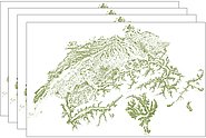
Swiss National Forest Inventory

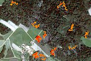
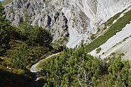
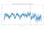
I lead / work for national and international projects and programs which are mostly related to forestry and supervise master and PhD students. I am associate editor of 3 Q1 journals and member of several scientific committees. My specific research interests are: Assessing state-of-the art and changes (natural and human-made) of landscapes, with focus on forests. To achieve this I use modelling techniques and high-resolution remotely sensed data: airborne digital sensors, Airborne Laser Scanning (ALS), and spaceborne sensors (GEDI, Sentinel-1/2, Landsat). My focus lies on machine learning approches and open data and software. I have particular research interests in spatially estimating forest parameters (area, structure, species, AGB, forest edge etc.) at different scales (stands, national to global) and the appropriate validation of these products. I have a strong interst in bringing together research and practitioners.

Keywords: Remote Sensing of Environment, Deep learning, Estimating Forest Parameters, National Forest Inventory, Tree Species, Forest Structure, Biodiversity, Wall-to-Wall Products, Copernicus Sentinel-1/2, Countrywide, Outreach, Validation and Interpretation

Projects

In the FNEWs project, a national remote sensing-based monitoring system for forest damage is being set up for Germany. In the WSL's work package the potentials of Sentinel-1 C-band data are analysed, demonstrated and operational procedures are designed.

The aim of the project is to generate annual vegetation height models for Switzerland based on satellite imagery from Sentinel-2. Within the framework of the Swiss NFI, a workflow will be implemented and the accuracy of the resulting products will be estimated.

Provide a simplified Swiss-wide forest fire-related characterization of forest fuel types and calculate and analyse drought and fire-related remote sensing indices derived from multispectral Landsat and Sentinel-2 data.

Information on the distribution of shrub forest is of broad interest. The aim of this project is a robust workflow to produce an up-to-date, nationwide and high-resolution distribution map of the two dominant shrub forest species in the Alpine region based on remote sensing.

In this project, countrywide LiDAR data is used to derive the structural composition of forest edges for the entire Central Plateau. This forest edge characterization provides a basis for assessing the ecological quality of forest edges.

On the basis of Sentinel-1 SAR data and using various test areas in Europe, a system is being developed to detect forest disturbances. The changes in the forest caused by disturbances are to be detected in the SAR data by means of time series analyses at stand level.

This project focuses on mapping tree cover through historical images to reveal decades of environmental change. The proposed B&WTreeNet is capable of cross-temporal semantic segmentation to address inconsistent tree cover features.

Publications

Senf C., Esquivel-Muelbert A., Pugh T.A.M., Anderegg W.R.L., Anderson-Teixeira K.J., Arellano G., … van der Maaten-Theunissen M. (2025) Towards a global understanding of tree mortality. New Phytol. 245(6), 2377-2392. doi:10.1111/nph.20407 Institutional Repository DORA

Bruggisser M., Wang Z., Ginzler C., Webster C., Waser L.T. (2024) Characterization of forest edge structure from airborne laser scanning data. Ecol. Indic. 159, 111624 (12 pp.). doi:10.1016/j.ecolind.2024.111624 Institutional Repository DORA

Fassnacht F.E., Mager C., Waser L.T., Kanjir U., Schäfer J., Buhvald A.P., … Skudnik M. (2024) Forest practitioners' requirements for remote sensing-based canopy height, wood-volume, tree species, and disturbance products. Forestry. doi:10.1093/forestry/cpae021 Institutional Repository DORA

Oehmichen K., Ackermann J., Adler P., Backa J., Beckschäfer P., Deutscher J., … Wimmer A. (2024) Ergebnisse des Fernerkundungsbasierten Nationalen Erfassungssystems Waldschäden (FNEWs). (Project Brief Thünen-Institut für Waldökosysteme, Report No.: 2177). Thünen-Institut für Waldökosysteme. 2 p. doi:10.3220/PB1712056632000 Institutional Repository DORA

Reinosch E., Backa J., Adler P., Deutscher J., Eisnecker P., Hoffmann K., … Oehmichen K. (2024) Detailed validation of large-scale Sentinel-2-based forest disturbance maps across Germany. Forestry. doi:10.1093/forestry/cpae038 Institutional Repository DORA

Adler P., Beckschäfer P., Hoffmann K., Jütte K., Kirchhöfer M., Koukal T., … Zielewska-Büttner K. (2023) Produkte für die Fernerkundung richtig nutzen durch Validierung. AFZ Wald. 78(13), 38-41. Institutional Repository DORA

Nasiri V., Beloiu M., Darvishsefat A.A., Griess V.C., Maftei C., Waser‬ L.T. (2023) Mapping tree species composition in a Caspian temperate mixed forest based on spectral-temporal metrics and machine learning. Int. J. Appl. Earth Obs. Geoinf. 116, 103154 (12 pp.). doi:10.1016/j.jag.2022.103154 Institutional Repository DORA

Soffianian A.R., Toosi N.B., Asgarian A., Regnauld H., Fakheran S., Waser L.T. (2023) Evaluating resampled and fused Sentinel-2 data and machine-learning algorithms for mangrove mapping in the northern coast of Qeshm island, Iran. Nat. Conserv. 52, 1-22. doi:10.3897/natureconservation.52.89639 Institutional Repository DORA

Waser L., Ginzler C. (2023) Landesweite Datensätze zum Wald mittels Fernerkundung - der Beginn einer neuen Ära. In Eidg. Forschungsanstalt für Wald, Schnee und Landschaft, WSL (Ed.), WSL Berichte: Vol. 134. Neue Fernerkundungs­technologien für die Umweltforschung und Praxis. Birmensdorf: Eidg. Forschungsanstalt für Wald, Schnee und Landschaft, WSL. 23-30. doi:10.55419/wsl:33059 Institutional Repository DORA

Ackermann J., Adler P., Koukal T., Martin K., Waser L.T. (2022) Fernerkundungsdaten zur Schaderfassung in der forstlichen Praxis. AFZ Wald. 77(2), 20-24. Institutional Repository DORA

Demirbaş Çağlayan S., Leloglu U.M., Ginzler C., Psomas A., Zeydanlı U.S., Bilgin C.C., Waser L.T. (2022) Species level classification of Mediterranean sparse forests-maquis formations using Sentinel-2 imagery. Geocarto Int. 37(6), 1587-1606. doi:10.1080/10106049.2020.1783581 Institutional Repository DORA

Toosi N.B., Soffianian A.R., Fakheran S., Waser L.T. (2022) Mapping disturbance in mangrove ecosystems: incorporating landscape metrics and PCA-based spatial analysis. Ecol. Indic. 136, 108718 (10 pp.). doi:10.1016/j.ecolind.2022.108718 Institutional Repository DORA

Wang Z., Ginzler C., Eben B., Rehush N., Waser L.T. (2022) Assessing changes in mountain treeline ecotones over 30 years using CNNs and historical aerial images. Remote Sens. 14(9), 2135 (22 pp.). doi:10.3390/rs14092135 Institutional Repository DORA

Breidenbach J., Waser L.T., Debella-Gilo M., Schumacher J., Rahlf J., Hauglin M., … Astrup R. (2021) National mapping and estimation of forest area by dominant tree species using Sentinel-2 data. Can. J. For. Res. 51(3), 365-379. doi:10.1139/cjfr-2020-0170 Institutional Repository DORA

Dostálová A., Lang M., Ivanovs J., Waser L.T., Wagner W. (2021) European wide forest classification based on Sentinel-1 data. Remote Sens. 13(3), 337 (26 pp.). doi:10.3390/rs13030337 Institutional Repository DORA

Malkoç E., Rüetschi M., Ginzler C., Waser L.T. (2021) Countrywide mapping of trees outside forests based on remote sensing data in Switzerland. Int. J. Appl. Earth Obs. Geoinf. 100, 102336 (10 pp.). doi:10.1016/j.jag.2021.102336 Institutional Repository DORA

Rüetschi M., Weber D., Koch T.L., Waser L.T., Small D., Ginzler C. (2021) Countrywide mapping of shrub forest using multi-sensor data and bias correction techniques. Int. J. Appl. Earth Obs. Geoinf. 105, 102613 (10 pp.). doi:10.1016/j.jag.2021.102613 Institutional Repository DORA

Tomppo E., Wang G., Praks J., McRoberts R.E., Waser L.T. (2021) Editorial summary, remote sensing special issue "Advances in remote sensing for global forest monitoring". Remote Sens. 13(4), 597 (4 pp.). doi:10.3390/rs13040597 Institutional Repository DORA

Waser L., Rüetschi M., Rehush N. (2021) Künstliche Intelligenz im Wald - der neue «Waldmischungsgrad LFI». Bündnerwald. 74(5), 54-57. Institutional Repository DORA

Waser L.T., Rüetschi M., Psomas A., Small D., Rehush N. (2021) Mapping dominant leaf type based on combined Sentinel-1/-2 data – Challenges for mountainous countries. ISPRS J. Photogramm. Remote Sens. 180, 209-226. doi:10.1016/j.isprsjprs.2021.08.017 Institutional Repository DORA

Afficher tout
×